Proyecto Ruta de los Dioses
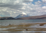
Sajama:
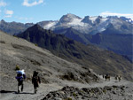
Sajama is an inactive Volcano at the center of a Ntional
Parkpark. Sajama is one of the highest snowpeaks on
the Andean mountain range at 6,542 meters above sea
level, sorrounded by Geysers, Hot Springs and rare
Keñua trees.
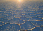
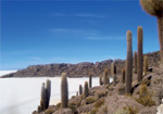
Uyuni Salt Flats:
In the South Eastern part of Bolivia lies the greatest
Salt Flat in the World, with an area of 10.582 Km2.
Like a great sea caressed by the southern winds, the
infinite whiteness of the salt flat merges with the dark
blue sky found only in the high altitudes to produce
wondrous mirages that may elicit transcendental
revelations for some, or merely joyous and playful
sensations for others.
Uyuni is regarded as the best star gazing destination in
South - America.
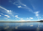
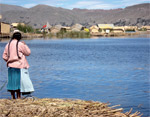
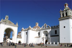
Titicaca Lake:
Titicaca is the highest navigable lake in the world at
3,810 meters (14,000ft) above sea level, and the
largest in South America with 8.300 Km2 .
It is known as the Sacred Lake of the Inkas, for it is
told that the two first Inkas, Manco Kapac and Mama
Ojllo descended on a golden disc onto the lake, and
therefrom started to look for the place to found the
empire, which was in Cuzco. The Island of the Sun is
therefore one of the most important pilgrimage places
in South America.
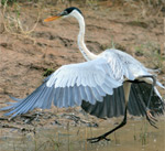
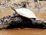
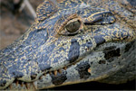
Pampas-Rurrenabaque:
Swim with pink river dolphins in this area of Savannah
(pampa), a very flat landscape divided by meandering
rivers and characterized generally by low and open
vegetation, ideal for animal observation: capybaras,
monkeys, anacondas - the largest land snake, caiman
and rheas. as well as a variety of birdlife from hawks,
ibises, screamers, herons, toucans, macaws and others.
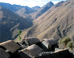
El Choro:
One of the most beautiful and better preserved Inca
roads, it used to connect the andean plateau with the
semitropical valleys, and used to exchange produce
such as coca and fruits from the low lands and
potatoes and quinoa and other grais from the
highlands. The highest point along this trail is in
Chucura at 4.800 m.s.n.m. and the lowest point on the
trail is in Chairo Village.
Takesi:
Also well know, this route traverses mountain passes
neighbouring beautiful snow peak Mururata, with
views also of Mt. Illimani. On the top of the trail lies a
beautiful glaciar lake, from there on it's steep
descending into the ever more lush valleys below with
parrots and jungle vegetation. The trailhead is at 3.200
m.s.n.m. and the mountain pass is at 4.640 m.s.n.m.,
ending up eventually at 2.200 m.s.n.m.
Apolobamba:
Cordillera de Apolobamba (Curva-Pelechuco)This trek
is unique because it traverses kallawaya territory.
Kallawayas are very renowned herbal and ritual
medicine men, who still mantain a unique ritual
language. One of their main places of pilgrimage, and
source of much of their curative strength and
knowledge come from their sacred mountain
Akamani, which we pass along this trek, and whose
impressive beauty and magnificent presence imbues
us with strength and insight.
Act. ML/2010